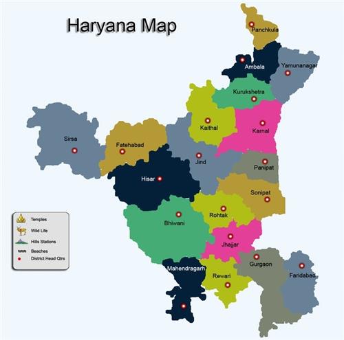
Geographical location of Haryana
- Haryana is a State in the northwest of India and was carved out of the Indian State of Punjab on 1st November 1966.
- With capital at Chandigarh which is administered as a Union Territory, this north Indian land locked state is located between 27º 39′ and 30º 35’N latitude and between 74º27′ and 77º36′ E longitude with just 1.37% of the total geographical area and less than 2% of India’s population.
- Almost 1/3 of the total area of the state falls in the National Capital Region. Haryana is an agrarian state whereas 85% of its area is under cultivation, engaging about 78% of its population in agriculture.
- Haryana has carved a place of distinction for itself during the past three decades, whether it is agriculture or industry, canal irrigation or rural electrification.
- Haryana is among the most prosperous states in India, having one of the highest per capita incomes in the country
Geography of Haryana
Haryana has four main geographical features.
- Shivalik Hills to the north east
- Ghaggar Yamuna Plain forming the largest part of the state
- Semi- desert sandy plain in the south west
- Aravalli hills in the south.
Shivalik Hills:
- These hills are the source of the rivers like Saraswati, Ghaggar, Tangri and Markanda. Parts of Panchkula, Ambala and Yamunanagar districts.
Aravali hills: This is a dry irregular hilly area.
Semi-desert sandy plain:
- This area includes the districts of Sirsa and parts of Hissar, Mahendergarh, Fatehbad, Bhiwani and shares border with Rajasthan.
Ghaggar Yamuna Plain:
- Divided in 2 parts – the higher one is called ‘Bangar’ and the lower ‘Khadar’.
- This alluvium plain is made up of sand, clay, silt and hard calcareous balls like gravel known locally as kankar
Physiographic profile of Haryana
- Physiography of Haryana sub-region mainly consists of plains made up of alluvium of Yamuna River with some pediments of Aravali.
- Almost all the districts of sub-region have similar characteristics except areas dominated by Aravali.
Panipat District
- Panipat district is a part of alluvial plain of Yamuna river.
- It slopes from west to east and water of the area flows towards Yamuna.
- Out of the two major physiographic units in the area, the flood plains are suitable for cultivation of rice and sugarcane.
- The other unit i.e. older alluvial plain spreading in the western part of the district is inclined towards the south and south-west area is irrigated by tube wells and canals and is a prosperous agricultural area.
Sonipat district
- Sonipat district may roughly be divided physiographically into three regions: The Khadar, the upland plain and the sandy region.
Rohtak district
- Rohtak district comprises of the vast IndoGangetic alluvial plains called older alluvial plain.
- This older alluvial plain is further divided into sand derived from the old alluvial plains is mostly from the Himalayan rivers having a heterogeneous composition.
Jhajjar district
- Jhajjar district comprises of vast Indo-Gangetic alluvial plains.
- The main physiographic components are
- Upland plains, being spread in the northeastern part of the district, covered with old alluvium soil possessing high productivity characteristics
- Alluvial Plains which are productive soils with good irrigation facilities (canal and tube-wells).
Rewari district
- Rewari district can be divided into four terrains i.e.
- Barren rocky/stony waste/sheet rocky
- Sandy plain with sand dunes
- Old flood plains
- Occasional hillocks and Undulating uplands with or without scrub.
- The Aravali are presently experiencing weathering and denudation.
Gurgaon district
- Gurgaon district comprises of both hills on one hand and depressions on the other, forming irregular and diverse nature of topography.
- Two ridges (i) the Firozepur-Jhirka Delhi ridge forms the western boundary and (ii) the Delhi ridge forms the eastern boundary of the district.
Mewat district
- Mewat district has distinct topographic features with flat alluvial plains over most of the region, long and narrow pediments and local undulations caused by windblown sands at the foot hill zones and the plains.
Faridabad and Palwal districts
- Faridabad and Palwal districts have mountainous physiography and have alluvium deposits.
- The alluvial plains have been divided into two units.
- Khadar that is the low lying flood plain of newer alluvium and Banger, an upland plain made of older alluvial and is spread towards west.
- There are also few artificial lakes namely Surajkund, Badhkal, Peacock and Dhauj Lake etc
- HPSC Mains Tests and Notes Program 2025
- HPSC Prelims Exam 2025- Test Series and Notes Program
- HPSC Prelims and Mains Tests Series and Notes Program 2025
- HPSC Detailed Complete Prelims Notes 2025
